If you’re eyeing a property in Sydney, the first question to answer is whether it sits inside a mapped flood extent, and the fastest way to find out is an address search on the NSW spatial viewer or a direct request to the local council for flood study extracts. Mapped categories guide planning controls, but they don’t guarantee safety in every scenario. When the result is unclear or borderline, a specialist flood report is the next sensible step.
TL;DR:
- Save the map’s publication date and cross check its written flood study; outdated modeling, unclear boundaries, and unmodeled overland flow can change a property’s exposure.
- The 1% AEP is a planning benchmark, not a worst case; larger floods can exceed it, and H1 to H6 rules vary by council.
- Mapped flood areas may require raised floors, materials that tolerate flooding, relocated services, engineering reviews, and longer approvals, so budget before planning renovations.
- Get insurance quotes before exchange, and use high premiums, remediation estimates, or a conditional flood report clause to guide negotiations and protect your offer.
Table of Contents
- How to check a property’s flood exposure in NSW
- What flood classifications like H1–H6 and 1% AEP actually mean
- Areas often flagged as not flood prone, and the map quirks worth knowing
- Building and approval requirements in a mapped flood area
- A due diligence and negotiation checklist for flood-affected properties
- How a buyer’s agent handles flood-risk properties on your behalf
- Director’s perspective: why early flood checks save buyers time and money
- How Sydney Property Buyers can help with a flood-affected purchase
- FAQ
How to check a property’s flood exposure in NSW
Before you get attached to a property, run it through the public mapping tools that councils and state agencies maintain. These won’t replace a formal report, but they tell you within minutes whether a closer look is warranted.
The main sources worth checking are:
- NSW spatial viewers and state map layers, which show flood planning areas and hazard extents by address.
- Council flood study PDFs, published by most Sydney local government areas, with detailed modelling for specific catchments.
- Public datasets from agencies such as the State Emergency Service (SES), which flag areas with known flood history and evacuation considerations.
To get a usable result, work through these steps:
- Enter the full street address into your council’s online mapping portal or the relevant state spatial viewer.
- Toggle on the flood-related layers (these are often labelled separately from zoning or heritage overlays).
- Note any labelled extents, such as the annual exceedance probability (AEP) flood extent, floodway or flood planning area.
- Save a screenshot of the map along with its metadata, including the date the layer was published and the source council or agency.
- Cross-check the result against the written flood study, since map colours alone rarely show design flood levels or hazard categories.
If the online map is ambiguous or has overlapping layers, unclear boundaries, or no obvious labelling, contact the council directly and ask for the specific flood study pages covering that property, the defined flood level for the site, and any notes on model limitations or data age. Some mapping platforms also pull in third-party services with their own privacy policies governing how address searches are handled, which is worth knowing if you’re using a tool linked to a larger platform.
When a property sits inside or near a mapped extent, or when the council flags it as requiring further investigation, it’s worth commissioning a Flood Risk Management Report. This should address the site’s specific flood planning level, likely depth and velocity in a design event, and any mitigating works already in place.
Pro Tip: Always request the flood study’s publication date. A map based on modelling from over a decade ago may not reflect recent drainage works or catchment changes.
Our guide to reading LEP land-use tables in the spatial viewer walks through the broader process of interpreting these tools before you sign anything.
What flood classifications like H1–H6 and 1% AEP actually mean
Flood reports and council letters are full of technical shorthand that sounds more alarming than it needs to be once you understand it.
The annual exceedance probability (AEP) is the standard benchmark used in flood planning and design across NSW. It describes a flood event with a certain chance of occurring in any given year, representing a planning tool rather than an absolute measure of flood risk. Technical reports commonly use the 1% AEP as the basis for setting planning and design flood levels, but it’s a planning tool rather than a full measure of extreme flood risk: rarer, larger events can and do exceed it.
Hazard categories, often labelled H1 through H6, describe how dangerous floodwater would be to people, vehicles and structures at a given location. These categories combine two factors: how deep the water gets and how fast it moves, sometimes expressed as a depth times velocity (V×D) figure. Hazard categories in many NSW studies are built from this depth and velocity combination, with lower numbers generally indicating calmer, shallower conditions and higher numbers indicating fast-moving or deep water that poses a real danger to people and vehicles.
A few terms worth knowing cold:
- Floodplain: the broader area that floodwater can occupy during a flood event, not just the main watercourse.
- Floodway: the part of the floodplain that carries the fastest-moving, highest-volume flow and is usually the most restricted for development.
- Overland flow path: a route water takes across land during heavy rain, which may not follow a mapped watercourse at all.
- Design flood level: the specific water height used to set building and planning requirements for a site.
One detail that catches buyers out: an H3 rating in one LGA doesn’t necessarily carry the same building controls as an H3 rating in a neighbouring council area, because each council sets its own development control plan provisions on top of the state framework.
Areas often flagged as not flood prone, and the map quirks worth knowing
Some properties sit genuinely outside mapped flood extents, and there are usually clear reasons why: higher local ground relative to the surrounding catchment, retained levee or drainage infrastructure, or simply being outside the modelled study area altogether.
That said, a “not flood prone” label on a map isn’t the end of the story. Worth keeping in mind:
- Flood studies are built at a certain resolution, and very localised low points or minor drainage lines sometimes fall below what the model captures.
- Councils typically note exclusions and assumptions in the written flood study rather than on the map itself, so the PDF report matters as much as the colour-coded layer.
- A property outside the main mapped extent can still experience overland flow or localised pooling during an intense, short-duration storm that the broader catchment model wasn’t designed to capture.
None of this means every property needs a full flood report. It does mean that a quick glance at a map, with no read of the underlying study, isn’t quite due diligence.
Building and approval requirements in a mapped flood area
If a property sits within a flood planning area, it doesn’t automatically rule out building or renovating, but it does change what’s required to get approval and what that work will cost.
Common design responses include:
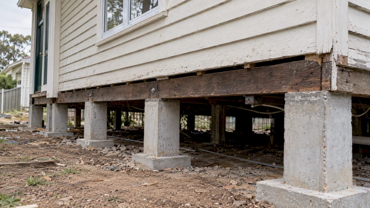
- Raising the finished floor level above the flood planning level, sometimes through elevated slab design or stilted construction.
- Specifying flood-tolerant materials on lower levels, such as tiled rather than carpeted finishes, and water-resistant wall linings.
- Relocating essential services, switchboards, hot water units and air conditioning compressors, above the flood planning level.
- Designing driveways, fencing and landscaping so they don’t obstruct flow paths during a flood event.
On the approval side, expect a merit-based assessment process rather than an automatic knockback. Councils typically request a flood impact assessment, evidence that the design won’t worsen flooding on neighbouring properties, and sometimes referral to a specialist engineering team within the council. Documentation requested often includes site-specific flood levels, drainage plans and, for larger projects, a full flood risk management report.
These requirements translate directly into cost and timeline. Raised foundations, additional engineering certification and extended assessment periods all add to a build, and it’s worth budgeting for both the construction premium and a longer approval runway before locking in a settlement date around renovation plans.
Pro Tip: Ask the selling agent whether the vendor has any existing council pre-lodgement advice, approved DAs, or prior flood assessments for the property. These documents can save weeks of your own research.
A due diligence and negotiation checklist for flood-affected properties
Flood exposure shouldn’t be a dealbreaker on its own, but it should shape how you approach the contract.
Work through this sequence during your due diligence window:
- Check the address against council and state flood mapping layers.
- Request the council’s flood study extract for the specific lot, not just the suburb-level overview.
- Commission a specialist Flood Risk Management Report if the property sits in or near a mapped extent.
- Get insurance quotes before exchange, not after, since availability and pricing vary significantly by insurer.
- Review easements and drainage infrastructure on title, since these often interact directly with flood controls.
A few things sharpen your negotiating position once you have this information in hand:
- Remediation cost estimates from a flood or building consultant give you a concrete figure to raise with the vendor or factor into your offer.
- Insurance premium quotes that come back notably high are a legitimate, evidence-based reason to revisit price.
- Conditional clauses, making the contract subject to a satisfactory flood report, protect you if something unexpected turns up after exchange.
On insurance specifically, private insurers assess flood risk property by property, and high-exposure floodplain locations often attract higher premiums or coverage restrictions, so a quote obtained early is worth more than any map reading on its own.
Red flags worth treating as a genuine pause point: a vendor unwilling to share existing flood reports, a council response that flags the site as requiring referral to a specialist flood engineer, or an insurance quote that comes back with exclusions rather than a standard premium. Our due diligence checklist for the Sydney cooling-off period and easement checklist before exchange both cover adjacent checks worth running alongside any flood investigation. If the property is being sold with known defects or condition issues tied to past flooding, it’s also worth understanding how vendors handle disclosure when selling property in any condition, since disclosure practices vary and affect what you’re entitled to know before exchange.
How a buyer’s agent handles flood-risk properties on your behalf
Flood checks are one of several technical hurdles that come up during a Sydney purchase, alongside zoning, easements and heritage overlays, and working through all of them while also searching for and negotiating on a property is a lot to carry alone.
As a buyer’s agent, we build flood exposure into the search itself, filtering out properties with unresolved hazard flags before you spend time and money on a pest and building inspection. Where a property is worth pursuing despite a flood planning overlay, we commission and interpret the specialist reports, then use the findings as a genuine negotiation lever rather than a reason to walk away prematurely.
- We run targeted searches that factor in flood mapping alongside your other criteria.
- We manage and interpret specialist flood reports so the findings are usable at the negotiation table.
- We translate council flood study language into plain next steps for your specific property.
| Service | Best suited for |
|---|---|
| Complete Purchase Solution | Buyers who want the full search-to-settlement process handled, including flood and due diligence checks |
| Negotiation Only | Buyers who’ve already found a property and need representation to negotiate price and conditions |
Director’s perspective: why early flood checks save buyers time and money
The buyers who get caught out are rarely the ones who find a flood overlay. They’re the ones who find it after they’ve already fallen for the property and stopped thinking clearly about price. One client nearly proceeded on a riverside property until an early flood report revealed a six-figure cost to meet the required floor level, information that reshaped the offer before exchange rather than after.
— Kristan
How Sydney Property Buyers can help with a flood-affected purchase

If you’re weighing up a property with any flood overlay, our Complete Purchase Solution covers the full process: strategy, search, independent appraisal, due diligence (including flood checks), negotiation and settlement. For buyers who’ve already found the right property and just need skilled representation at the negotiating table, Negotiation Only gives you that support without the full search engagement.
Engagement starts with a retainer that’s deducted from the final fee at settlement, and we provide services across multiple Sydney regions including Inner West, Eastern Suburbs, Lower North Shore and Eastern Beaches.
- Full-service buyers get flood risk built into the property search from day one.
- Negotiation-only clients get flood findings turned into leverage at the table.
- Both services draw on access to off-market stock not available through public listings.
Get in touch on 1800 676 177 or hello@sydneypropertybuyers.com.au, or view our full service details to find the right starting point.
FAQ
How can I check the flood zone of a NSW suburb using my address?
Enter your address into your local council’s online flood mapping portal or the NSW spatial viewer and switch on the flood-related layers. For a complete picture, follow up with the council directly for the written flood study covering your specific lot, since the map alone rarely shows design flood levels or hazard categories.
Is flood zone A or AE better?
These labels come from different mapping systems than those typically used in NSW, so the answer depends on which framework a specific map or report is using.
Which is worse, flood zone 2 or 3?
Zone numbering conventions vary between mapping systems and aren’t the standard terminology used across NSW flood studies. In NSW, hazard is generally expressed through H1–H6 categories based on flood depth and velocity, where higher numbers indicate more dangerous conditions for people and vehicles.
Is flood zone C good or bad?
This labelling isn’t a standard NSW flood classification, so it’s worth checking which mapping system or jurisdiction the term comes from before drawing conclusions.
Recommended
- Buyers: Read LEP Land Use Table in Spatial Viewer before you sign
- NSW Buyers: 6 Step Easement Checklist Before Exchange
- Strata by-laws in NSW: what buyers and owners need to know
- Section 32 explained: what Sydney buyers need to know